In the two previous posts of this series (Part I, Part II) I looked at North/South routes, both ideal and second best. This post will continue by looking at East/West routes with the same perspective in mind. Just as there are continuous N/S routes but none of them are planned to get a cycling treatment, so there are E/W routes that are not planned to get a cycling treatment, or which have been so long delayed I am skeptical of follow through. In all fairness, there are fewer such routes in this direction; however such routes as do exist are so dangerous it would actually serve us well to rebuild them with facilities. Indeed one of them, Lowry, is set for just such a rebuild. The geography of Northeast is complicated, so some routes I will discuss here are not strictly E/W, but they are predominately E/W and function in tandem with the N/S routes.
In the far north, the very boundary of the city, there is 37th. Thankfully this is being rebuilt with a two-way cycle track. Certain sections of it are already complete and are pretty nice. Inasmuch as this street only serves a small bit of the neighborhood, it’s not important enough to spend too much time on. But as part of an entire network, it is nice to have.
Heading south, the next continuous route is actually already equipped with a two-way track. St. Anthony Main is part of the “Grand Rounds,” and while certain parts of it aren’t in terribly great condition, on the whole it’s nice to have. Its meandering path connects us to North Minneapolis. In truth I have only ever had occasion to use it a few times, and only for pleasure rides. Altogether too much attention is given to the Grand Rounds in this city. It is a loosely connected series of recreational trails. It’s great to have recreational trails, but outside of being integrated into a completed network, recreational trails are not as efficient or useful as more direct routes. So, for instance, as far as Northeast goes, the majority of this route runs through a park and rail yard, and the rest through a purely residential area. As with 37th, it’s nice to have, but is only moderately useful in the context of transportation.
And transportation is the thing we need. The most basic question that needs addressing in this series of posts is: Where do we need to get to? Not only within the neighborhood itself, but to what adjacent neighborhoods, and for what purposes? There is nothing to the north of Northeast. Nothing to the east of it. To the west is North, so we’ll need routes into it. To the southeast we’ve got Dinkytown, Como, Prospect Park, and St. Paul. Direct routes should be provided into them. But what is directly adjacent to NE is Downtown, and every remaining part of the city is accessible exclusively through Downtown. Downtown is where sports, arts, jobs, and regional transit are. It is either the primary destination, or the place through which one must pass on the way to other destinations. And as it stands, there is not a single safe route from NE to either DT or Dinkytown. From this point in the discussion on, proposed routes should be oriented to Downtown and Dinkytown. From a transportation perspective, almost nobody is hoping onto the 22nd Ave Bicycle Boulevard and heading West for a destination on the river road. We take it to turn south onto Monroe, 5th, or Marshall so that we can get to elsewhere. As far as job and population density, by far the greatest concentration is in DT, in Dinkytown, and in areas immediately south of DT. This tangent risks ruining the structure of this post, which is moving from the top to the bottom of NE, but it’s a key contextualization of the discussion that needed to be there. Because often times planners and even advocates can get excited about “miles added,” yet are so disconnected to the neighborhood’s transportation needs I sometimes wonder if they’ve ever been to NE. This will become important when we get to “The Great Northern Greenway,” or what I call “18th Ave.”
The next potentially important E/W route, 29th Ave, cannot cross the entire neighborhood because of the rail yard. On the All Ages and Abilities Network it has the status of “Connector or Long-Term Low Stress Bikeway.” The asphalt of the street as it stands is in shambles, quite possibly the worst condition surface in the neighborhood. The southern sidewalk is so narrow and poorly kept that in the winter it will not infrequently provide a mere 16 inches of walking space next to light poles, even when the city clears it where it runs along Audubon Park. Yet the space allotted to cars is gargantuan, comfortably providing two traffic and two parking lanes with room to spare. Yet it was recently downgraded from a full rebuild to a temporary surface treatment. It’s possible that it will get a plastic bollard separated two way track (from Central to Johnson?), but this is uncertain. 29th is important for multiple reasons:
- It provides a direct route to Northeast Middle School
- The grade is mellower as it rises to Upper Northeast and so makes a good companion to 27th and St. Anthony Parkway
- It runs along a large park
- It provides access to businesses on Johnson
- If Johnson were properly built from 37th to Lowry it would be a key route in the AAAN as it goes south into Dinkytown
- Johnson is where one can catch the 4 bus
- And if 29th received a full makeover it would also serve the goal of connecting municipal cycling facilities to the regional trail into Roseville
For all the years she went to Northeast Middle, my daughter walked from our place to school. The current state of things made this more hazardous than it should be. As I think I’ve shown, there are multiple strong reasons it should be upgraded to a curb and grade separated “low stress bikeway” for cyclists, and the sidewalks need significant widening and better winter maintenance.
27th Ave is the first E/W route that can cross the entire neighborhood. Well, almost. It is on the AAAN, and on the west side of the railroad tracks already fitted out with a plastic bollard buffered lane. It seems to be going through some reconstruction and, according to Mpls design standards that means it should get a sidewalk-level treatment, either a shared path or two one-way lanes. Whether the city will follow through with their commitments remains to be seen. 27th gives a relatively gentle grade climb into Upper Northeast, and so it is fitting as an AAA route. It also crosses Central, which means it will connect to the coming Bus Rapid Transit line. The only problem is the rail tracks where it dead-ends at 6th St. In order to make a complete run, some kind of accommodation needs to be constructed over the tracks. It would be brilliant if it could be a ped/cycle bridge – no cars allowed, but even an 8ft strip of asphalt would work for now. What we are told in NE all the time is that the rails are why we can’t have nice things. This seems to me a cop-out for not working with a partner to achieve our goals, something that is front and center on the Minneapolis Transportation Action Plan. At other points in NE we have Harrison St, 12th Ave, 14th Ave, and W Island Ave, which are all at-grade crossings. It’s a thing we can do. Only a few days ago we got news that trails will be connected in partnership with BNSF on the north side of the river.
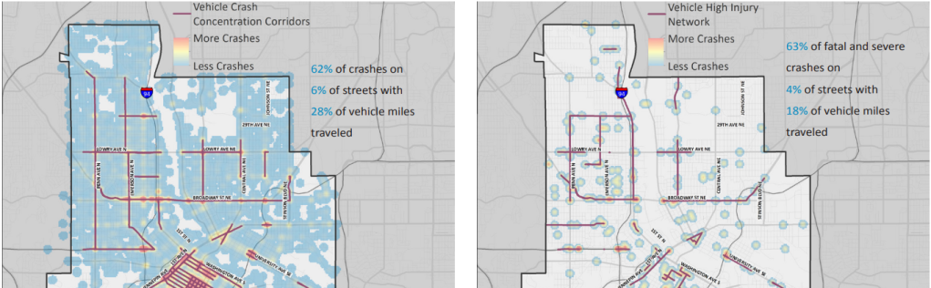

What we have above are images from both the 2018 and the 2022 Minneapolis crash studies, whose combined data covers 14 years of crashes and injuries. What is crystal clear is that the deadly and dangerous streets of NE are known, and have been obvious for some years. It’s not until this year that anything has been done about it. Lowry Ave is one of those deadly streets, and it is getting reconstructed starting this year. Unfortunately the first stage will only rebuild from Washington to Lowry, but the project is supposed to be complete (in NE) from Lowry to Marshall in the end. I welcome this change.

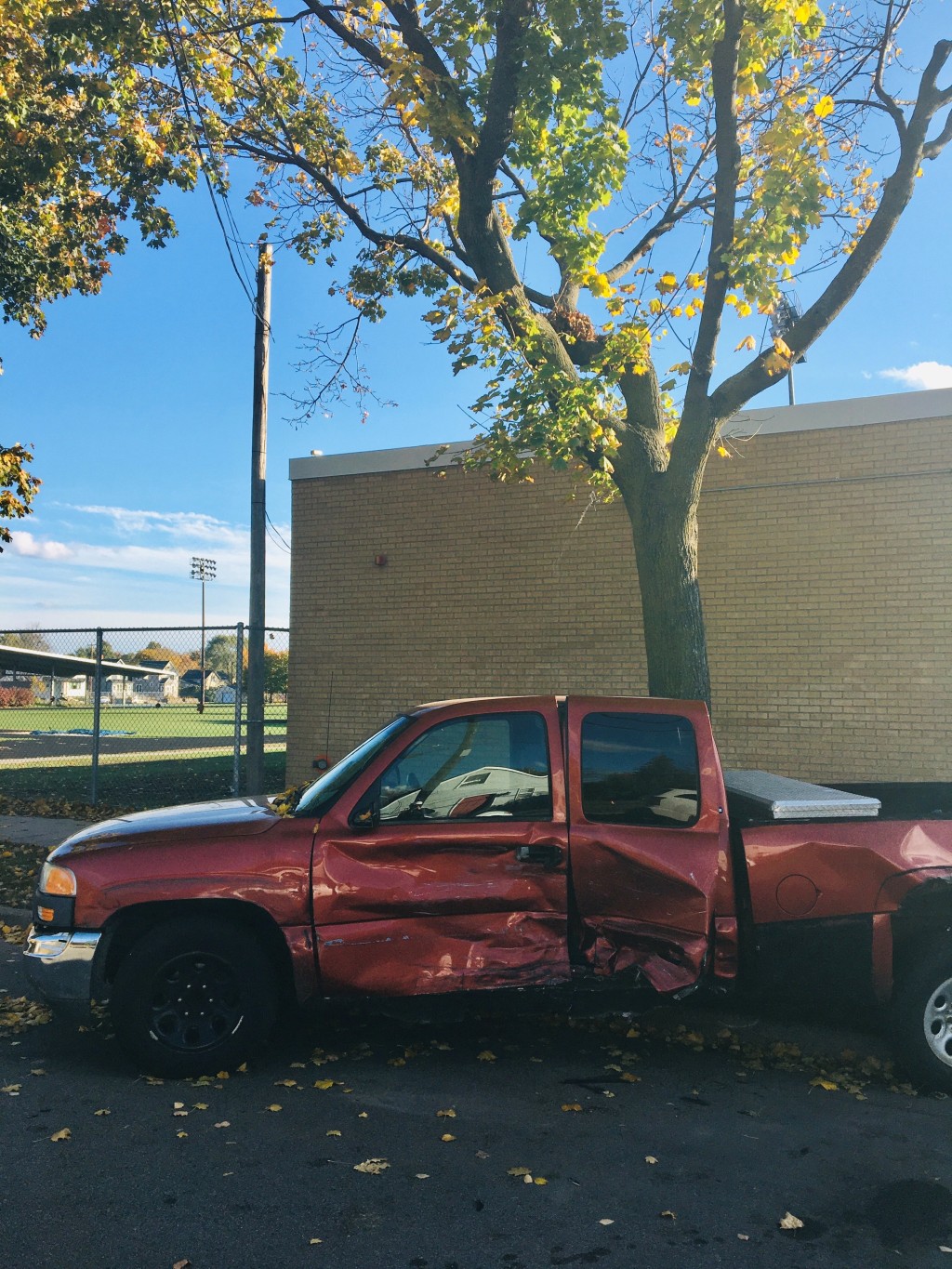
I took the title photo and this one of a truck so forcefully hit by another vehicle that it was lifted off the street and wrapped around a tree. This was on one of my daily routes, one of the routes my children take to get to friends’ houses, and to their school, Edison High School, which is a mere block away from this incident. It took place on 22nd Ave, which is an official bicycle boulevard. 22nd is one of the few continuous E/W routes in NE that isn’t Lowry or Broadway, so it is a logical choice and should have a high priority in the neighborhood. It runs to the neighborhood high school, and connects to pretty much every AAA route that runs N/S. Surely as part of the All Ages and Abilities Network it should look forward to some significant work, right? Well that introduces new information I discovered that answers a question I posed in the previous post in this series.
I noticed that some current bicycle boulevards in NE had disappeared on the AAA map, and I wondered also whether “existing bikeways” on the AAA would be built to conform to the standards of the AAA where they did not. The implication of the phrase “already existing” suggests, on a grammatical level, that they were already complete and so would not see future changes. Yet this was vague because the AAA is clear:
The term “Neighborhood Greenways” will replace the term Bicycle Boulevard. And Neighborhood Greenways “differ from bicycle boulevards because they will optimize travel for pedestrians and bicyclists by eliminating or significantly reducing motor vehicle use. Neighborhood greenways will also greatly improve the walking environment throughout the city by limiting interactions with motor vehicles and improving the experience of crossing the street.”
If, then, Bicycle Boulevards have been replaced by Neighborhood Greenways, and if Greenways differ from Boulevards by their significant safety improvements, logically the “existing bikeways” in NE that are “Bicycle Boulevards” will be made AAA compliant. However, in the Minneapolis Street Design Guide, which was written after the AAA because it references it, Bicycle Boulevards have been reintroduced, and they have been declared by fiat to be an AAA facility without any of the safety and design considerations that Neighborhood Greenways are supposed to get. They get around this contradiction by calling them “Neighborhood Greenway: Bicycle Boulevards,” just straight up mashing the terms together. This is clearly a rearguard ex post facto move to allow currently existing Bicycle Boulevards to skirt a proper AAA treatment, and legitimize their future use in the AAA.
This is unfortunate, and calls into question the City’s commitment to Vision Zero and the Transportation Action Plan. Because Bicycle Boulevards are not infrastructure. Boulevard streets are left entirely unchanged outside of a few painted cyclists on the ground and, maybe, if we’re lucky, a speed bump or roundabout or two. But we won’t see any parking eliminated, traffic discouraged, intersection safety improvements, and so on; that is to say, nothing of the good and noble features seen in sections 3.4H and 3.4I of the Design Guide for “Full Greenways.”
On that note I will close this post. The next one will start with “The Great Northern Greenway,” the discussion of which would make this post even more unwieldy than it already is.

Leave a comment