I began this irregular blog because I felt a gap in the alt-cycling world where urban, transportation cycling had once been. But this is not the first place where I have written about cycling in Minneapolis. I used to write for StreetsMN, a publication focused on issues under the urbanist umbrella: Housing, transportation, infrastructure, and so on. I started writing there because, though I contact my local representatives, I’m not really an organizer. What I can do for the city is write pretty well, and analyze as an educated and experienced layman. Councilors and staff actually read StreetsMN. I have gotten around Minneapolis almost exclusively by bike for over a decade, so I am intimately familiar with the many paths one may take to get around. I am educated in history, philosophy, and politics, which allows me to take a big picture, humanist approach to analyzing urban policies. I am convinced that if one starts from a “what is politically realistic?” position, one has already given up asking the substantial question. By so doing one avoids speaking of the goal toward which urban planning is aimed. It may – of course! – be difficult to attain certain levels of cycling infrastructure in the near term, but that does not mean we must handle a bike lane with kiddy gloves or steeled “realism.”
Because as it stands, “being realistic” functions as a blank check of defense. One cannot legitimately critique what is (we are told) “iMpOsSiBLe.” Minneapolis has once again been given the title of “Best Cycling City in America.” From what organization does not really matter. What matters is we get to claim it. Such an award, for me, as someone who has actually ridden bikes in Copenhagen, feels like the inflected doting of a parent telling a kindergartener that their crayon drawing of a bike lane is amazing. “You’re so talented!” In point of fact there have been a few recently completed projects that, as far as they go, are honestly quite splendid. I’m thinking particularly of Bryant. And yet my phrase “as far as they go” is intentional, and I hope slightly barbed. Because despite these recent accomplishments, some of which – again – really are great, as yet Minneapolis has studiously avoided connecting these sections into an integrated network. They pop up only to disappear a few blocks later, often fizzling out entirely at intersections, or near Downtown: Where our cycling network goes to die.
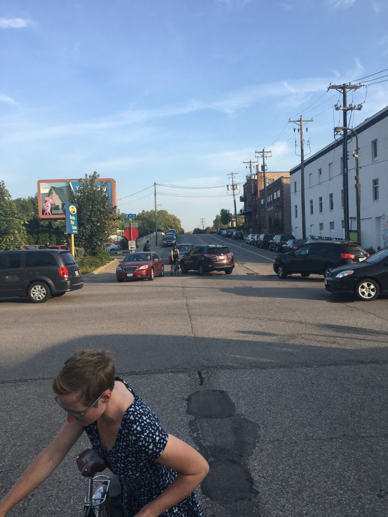
I am not yet intending to write about all of Minneapolis’ cycling infra. What will concern me in this series is the curious case of Northeast Minneapolis in particular. My neighborhood for the last 20 years. The starting point and terminus of all my rides, whether to work, to play, or to groceries. What is curious about NE is that, whereas every other part of Minneapolis has been receiving significant investment in new infrastructure, we have gotten…nothing. Nada. Bupkiss. In effect, NE has no real cycling infrastructure.
When I made this claim on social media I was met with some skepticism and outright disagreement. And I will admit to using the rhetorical tool of hyperbole, for which I will not apologize. I did not receive a classical education simply to write as if I have never read Lysias. But yes, let us grant that there are a couple instances of new infra projects in NE. One of which in particular is a roaring success in my opinion…as far as it goes. And it does go- until it disappears at an intersection, emptying out into nothing. I will write of this in due course. Yet because each of these projects, including one yet to come, terminate at both ends into nothing – connecting nothing to nothing – they are in effect not infrastructure properly so called. If a major city’s neighborhood had three paved streets that turned into a mixed traffic gravel road after a few blocks, we would not consider that infrastructure. So likewise, “greenways” that run straight into a train bridge at one end, and a recreational trail to a cemetery and industrial park on the other, can barely be considered infrastructure.
For the sake of this series, I will assume several uncontroversial things:
- “Bicycle Boulevards” in their current form, are not infrastructure. They’re a couple painted bikes and a nice smile. According to the bicycling section of Minneapolis’ 2020 Transportation Plan, which I have read in its entirety, planned “Neighborhood greenways,” which term replaces “Bicycle boulevards” from the former plan, are “routes that enhance local, low volume streets and give priority to people walking, biking and rolling. This will include removing or significantly limiting motor vehicles along sections of the street.” They are claimed to be different than and an improvement on the former. I guess we’ll have to wait and see, because they have yet to materialize. In their absence, then, I will continue to use “Bike boulevard” and continue to invalidate them as infrastructure.
- Painted door lanes are not infrastructure. They are painted lines and a nice smile, but far more insidious than bike boulevards because they are dangerous. The All Ages and Abilities Network (AAAN) admits as much (pg76). In the rare instances where they appear in NE, they terminate randomly and disappear at most intersections.
- Which introduces two additional assumptions:
I – Intersections are the most dangerous places for cyclists.
II – “Logical beginning and end points, typically connecting to other bikeways on the AAAN” is a pretty good starting point for deciding when a section of infrastructure is legitimate. That is to say that absent such logical points of network connection, isolated sections of infra are recreational paths, not infrastructure. - Recreational paths are not infrastructure except where they are a logical part of a cycling network. Recreational paths are delightful to have, but for this series I am interested in transport, not sport.

All that has been said so far has been but a prologue. Let us begin with “logical beginning and end points.” If the goal is a full network that allows cyclists to follow a continuous route through its area of the city and into others, there are rather obvious candidates. And they are, at the end of the day, the only routes available, because NE is bisected by a golf course and gigantic rail yard in the north. In the North/South direction, we’re looking at Stinson, Johnson, Central, University, and Marshall. There are several others that will work south of 27th Ave, but for now we will focus only on continuous routes.
Stinson, is about 1/3 of the way there already. South of Tartarus (its treacherous intersection with New Brighton Blvd) the eastern fork of the Diagonal Trail heads into Como (where it dissolves at Como). The picturesque section from Tartarus to the St. Anthony Parkway has no provisions for cycling. North of the Parkway there’s enough right of way to accommodate (I’m spitballing here) 5 or 6 car lanes. We could easily put in, at the very least, a Blaisdell style two-way up to the forthcoming 37th Ave NE project, which when finished hopefully will connect to North, if by a circuitous route around the rail yard. Sadly, if the map of the AAAN is any indicator, the best we can hope for is a couple painted lanes north of the Parkway. And as we have already established, that’s not infrastructure.
Johnson is a sad story because it appears that it will remain but a partial success. From Lowry to 18th Ave it has recently undergone a huge rebuild. What’s wonderful is that it was not done by any half measures. Curb and boulevard separated two way cycle track; bump outs; no passing; one lane in either direction; limited parking; beg lights at one bike boulevard intersection. You can tell that drivers want desperately to go faster on this section of Johnson, But. They. Can’t. Because instead of some nice yard signs declaring that “20 is plenty” and a quaint suggested speed limit, the actual build of this section of Johnson would force any potential passing vehicle onto a sidewalk. If someone is turning left, drivers must wait, for there is no where to go. Unfortunately this section terminates into oblivion at Lowry and there are not plans to extend it north at all, let alone to 37th. In this way Johnson is a failure precisely to the extent that it is a success. It remains unclear what will continue south after 18th Ave. The map indicates a “low stress bikeway” will head into Dinkytown, but as far as I can tell the AAAN never defines what a “low stress bikeway” is.
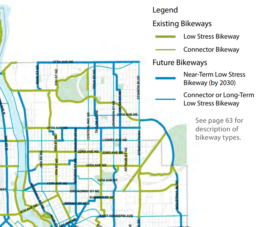
With Central we run into the biggest let down of this whole thing. Central offers not only a clear shot north and south through the entirety of NE, not only does it provide two ways into Downtown (one of which shoots right next to the Blaisdell/1st and Park/Portland loops), but it’s getting a Bus Rapid Transit line in a few years. Which isn’t even to mention the once talked about Central-Nicollet LRT line that was lost to the sands of time. Central has all the potential to be the backbone of a multi-modal alternative to the car. But it belongs to the county. And the county is plenty happy to continue to allow its inter-city highways to be the most deadly routes in all of Minneapolis. There are brief sections of painted door lanes from 27th to Broadway, but they sputter in and out, usually precisely where they’re needed (intersections). I’m a confident, experienced rider and I never use them. They’re entirely worthless, and non-existent anyway from Broadway into Downtown.
The story of University is basically the same as Central. Prime N/S route, even less travelled than Central, a straight shot into Dinkytown (and StP), easy connection to Downtown and the Stone Arch bridge. It’s got some ok painted lanes from Central into Dinkytown, but they’re not actually separated. It’s a stretch where I was hit by a car, so it’s not “low stress” to say the least. University will remain unsafe for cycling.
With Marshall we get our first chance of success, if only partial. It is unclear what kind of treatment is coming, but some kind of “low stress bikeway” will connect the north of NE to Downtown. We can hope that intersections will be safe, but there is no guarantee of that. And infuriatingly the coming rebuild of Lowry will terminate at Washington. Some labyrinthine path will have to be determined by each individual rider to get from Lowry & Washington to Marshall, but we will get to East/West routes on another day.
An astute reader will notice that with Marshall I have passed into what will be, rather than what is. Having waited 20 years, I may have to wait another 7 to get even one full north/south route that is safe (a word I like a lot better than the amorphous “low stress”). God only knows how long I will have to wait for the east/west route to get to it. Marshall excepted, every potential route mentioned won’t happen. In the next post I will turn to what could happen. What north/south routes begin and end in a logical fashion? Is there overlap with what seems to be planned in the AAAN? We shall see.

Leave a comment